Virga
“Save a boyfriend for a rainy day - and another, in case it doesn't rain.”
--Mae West
One of the questions that often appears on both the Canadian PPL and CPL written exams centers around the dangers of flying into virga. It is a question many licence candidates miss; they have had no personal experience with the phenomenon of virga, have never seen it in person, and, perhaps, it was not well taught by instructors who also have had no experience with it.
Virga is a very interesting weather phenomenon, both visually and technically. It is commonly seen by pilots operating in desert areas over the U.S. West and above the Canadian prairies. It can also be encountered in the Middle East, Australia, North Africa, and it has been seen in Sweden.
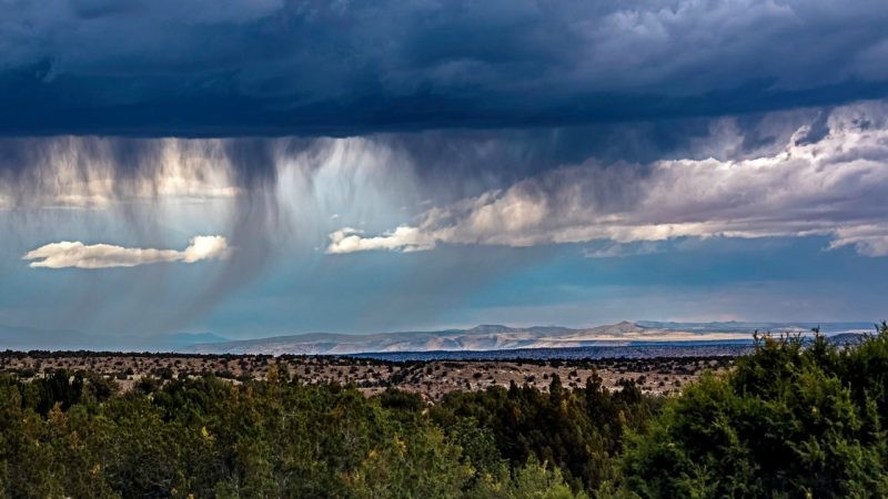
Basically, virga is precipitation: most often rain, but it may also consist of snow or ice under the right conditions. It is precipitation that evaporates, if it is in the form of rain, or sublimates, if it is in the form of snow or ice crystals, before it reaches the ground. The name virga is derived from Latin meaning “twig” or “branch,” and that is how it appears in the sky. Visually, virga often appears in streaks or shafts extending from the bottom of clouds, streaks or shafts that do not reach all the way to the ground. It is sometimes referred to as fallstreaks, a nicely descriptive name. Virga is an especially dramatic sight at sunrise or sunset.
Virga is the product of particular conditions. It is created when precipitation, rain or snow, falls from high clouds into extremely low humidity dry air and high temperatures. As the liquid raindrops or ice crystals fall into hot, dry air below, they begin to absorb heat energy from the surrounding atmosphere. As the molecules of the water droplets, snowflakes, or ice crystals absorb energy from the surrounding warm, dry air, their molecules become energized, their Brownian motion accelerates, and they evaporate or sublimate from liquid or solid states to gaseous states becoming water vapour or rain. In the process of changing state from liquid or solid to a gaseous state, considerable heat is absorbed from the surrounding atmosphere, cooling it.
When materials change state, for example from liquid to gas, evaporation, or from liquid to solid, freezing, they give off or absorb energy as part of the process. When ice melts to become water, it is changing state from a solid to a liquid. The liquid state of water is a higher energy state requiring more energy to maintain its state. We refer to this process, evaporation, as an endothermic reaction: energy is absorbed from the environment to achieve the change in state. The absorption of energy produces cooling in the surrounding environment. When water changes from its gaseous state to its liquid state, condensation, we refer to this as an exothermic reaction. Heat energy is released because the liquid state of water requires less energy than its gaseous state. The surrounding atmosphere gains energy through this state change. This is a common occurrence when relatively warm air rises into a cooler atmospheric environment forming clouds at the altitude at which the air becomes saturated.
Water in its solid form, ice or snowflakes, can sublimate directly from a solid state into a gaseous state. This state change requires a considerable amount of energy which must be drawn from the surrounding environment causing considerable cooling. We refer to this state change as being endothermic; it absorbs energy from its surrounding atmosphere.
In virga-creating situations, as precipitation continues to evaporate or sublimate, the surrounding air becomes increasingly moist and is cooled. If the precipitation is light, it can take several hours for the surrounding air to become saturated. If precipitation is heavy, the formation of virga is accelerated. As the air saturates first aloft then down to the surface, a kind of “moist pathway” is carved out of that precipitation and can eventually follow to the surface as rain or snow. This process is what creates and sustains the unique visual effects identifying the phenomenon as virga.
It is also theorized that virga is partially responsible for creating the so-called hole-punch clouds, another very interesting phenomenon I have had the pleasure of seeing only once in my flying career. In addition, virga high in the atmosphere can reflect sunlight creating brilliant sun pillars and other atmospheric optics associated with sunlight.
Hole-punch clouds, sometimes called fallstreak holes, arecomposed of small water droplets that are below freezing called supercooled water droplets. If ice crystals can form in the layer of supercooled droplets, they will grow rapidly and shrink or possibly evaporate the droplets completely.
Studies, including one carried out by Andrew Heymsfield and collaborators working at the National Center for Atmospheric Research,[i]have shown that aircraft passing through these cloud layers made up of supercooled droplets can trigger the formation of the heavier ice crystals which fall to Earth and then leave the circular void in the blanket of clouds.
According to Heymsfield, “This whole idea of jet aircraft making these features has to do with cooling of air over the wings that generates ice.”
His team found that, at lower altitudes, jets can punch holes in clouds and make small amounts of rain and snow. As a plane flies through mid-level clouds, it forces air passing over its wings to expand rapidly and cool. Water droplets in the cloud freeze to ice and then turn to snow as they fall. The gap expands to create spectacular holes in the clouds. [ii]

- Punch-Hole Cloud over Abbotsford, BC Jan. 28, 2019 3:05 p.m (local time)
While virga can be quite spectacular visually, it can also pose serious potential problems for pilots as a result of strong convective wind gusts and descending air. The inherent potential danger of flying into virga is a direct result of the rapid cooling of the air through which virga is falling and being created.
We all know that warm air will have a strong tendency to rise, and cool air aloft will have a strong tendency to descend. When virga develops, we can expect rapid cooling of the air below the cloud layer and potentially strong convective wind gusts as the air is cooled and descends. Strong and potentially gusty descending air is not a happy place to find yourself while piloting an aeroplane.
If your operations area includes conditions suitable for the formation of virga, it is a wise plan to become familiar with the visual clues necessary to identify it from a safe distance and to plan a flight route that will keep a safe distance from the potential hazards involved.
[i]https://ncar.ucar.edu
[ii]https://earthsky.org/earth/andrew-heymsfield-on-hole-punch-clouds-made-by-jets
First Officer at Sunwing Airlines
4yGreat write-up, Alex!